Sunday, November 19, 2017

Coastal erosion on Panama

As covered in past posts, we know that Panama has two seasons. A dry season, and a rainy season. In it's rainy season Panama can see as much as 75 inches of rain. This can create many problems, such as soil erosion. This has been a big issue of discussion regarding the Panama Canal.

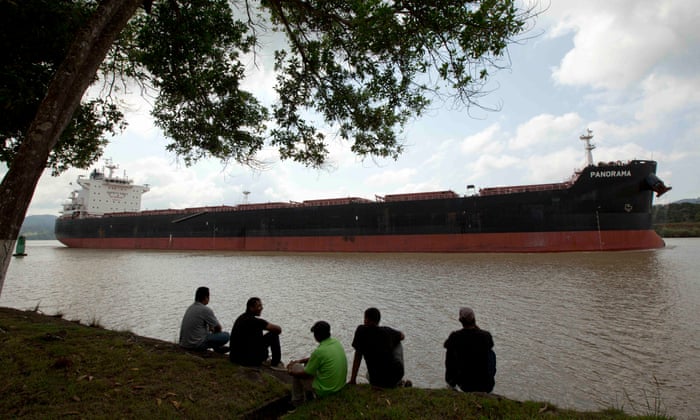
The Panama Canal is used as a passageway for ships to cross through Central America and come out of the other side instead of having to go all the way around the tip if South America. This short cut can save ships thousands of miles and money, if they fit of course. Not all ships do however. To correct this, the Panama Canal has undergone renovations to expand the canal. This will allow more and larger ships to pass through which would of course bring in more income.

The biggest set back to this is soil erosion. The excavation digging has caused loose sediment to float into the water due to the lack of vegetation which can have a negative effect in the water. To avoid this, the Panama Canal Authority has elected the aid of a product that can NaturesOwn X9000. This product is a fiber mulch material that excels in soil erosion prevention. It has been testing in the rainforests of Panama and has succeeded in protecting the local vegetation after the heavy rainfall.

This article that I came across is a perfect example of how a natural hazard can effect the country, and how the government has come up with a solution and help prevent future damages. If this is applied to the excavation site and works, this can boost the local economy and bring in more business and expand tourism. This is a great example of how the country has stepped up to find a solution to a natural hazard.

“Soil Erosion in the Panama Canal.” Storm Water Solutions, 14 Sept. 2012, www.estormwater.com/soil-erosion-panama-canal.

Sunday, October 29, 2017

Panama's EXTREME Weather

Panama may seem like a beautiful paradise, however the tropical weather can take a turn. Unlike the weather we may be used to with four season, or the idea of four seasons for some, Panama only has two. A rainy season and a dry season. The dry season usually spans from December to March, and the rainy season is from the middle of March to December. This may not seem too bad although we have learned in our past chapters that too much rain can lead to a whole slew of problems such as flooding and mudslides, and even hurricane warnings.

Another weather event that residents of Panama can experience is El Nino. This can cause high temperatures which comes from the warm water. In 2016, a warning was issued to alert ships entering the Panama Canal of lower water levels. This was caused by a drought caused by El Nino.


“Panama Canal Issues Extreme Weather Warning.” Port Technology, www.porttechnology.org/news/panama_canal_issues_extreme_weather_warning.

Canelo, Abelardo. “Hurricane Alert on Panamá and Costa Rica.” The Costa Rica News, NOAA, 7 Oct. 2017, thecostaricanews.com/hurricane-alert-panama-costa-rica/.

“Panama Canal getting shallower due to El Niño drought, ships warned.” The Guardian, Guardian News and Media, 21 Mar. 2016, www.theguardian.com/world/2016/mar/22/panama-canal-getting-shallower-due-to-el-nino-drought-ships-warned#img-1.

“What is ENSO?” El Niño & La Niña (El Niño-Southern Oscillation) | NOAA Climate.Gov, NOAA, www.climate.gov/enso.

Saturday, October 14, 2017

\
Unfortunately, landslides are quite common on Panama. The most recent occurred September 30th, 2017.  Six people were reported dead and another four were found injured. Those dead were a family who were found in their home which resided in the path the of the landslide. This event occurred in Cerro-Colorado, Panama.


Tropical storm Otto has also triggered some landslides in the country.

Civil Defense workers look the area where a couple was killed after their home was destroyed by a mudslide in Arraijan on the outskirts of Panama City, Tuesday, Nov. 22, 2016. Civil defense officials in Panama say the country has already seen three deaths blamed on late-season Tropical Storm Otto. (AP Photo/Arnulfo Franco)

The government issued some tips in ways to stay safe such as staying indoors during a storm, seeking shelter, and staying aware of water such as rivers and streams in case of a flood. In an article I found published in 2015, the Government released a statement of preparedness. This list included having an evacuation plan, planning at least 2 evacuation routes, avoiding water and low areas, and being aware of your surroundings. This means keeping an eye and ear out for debris coming your way. They also mentioned that should you notice that water levels near you are rising then you should evacuate the area as soon as possible and get to a safe location.


Associated Press. “3 dead in Panama rains linked to Tropical Storm Otto.” Fox News World, FOX News Network, 22 Nov. 2016, www.foxnews.com/world/2016/11/22/3-dead-in-panama-rains-linked-to-tropical-storm-otto.html.


“Floods and landslides in 6 areas.” Newsroom Panama, 16 Oct. 2016, www.newsroompanama.com/news/panama/floods-landslides-6-areas.


Rodriguez, Vladimir . “Government of Panama reiterates support for all those affected by floods in the country.” Gobierno De La Republica De Panama, 11 Sept. 2016, www.presidencia.gob.pa/en/News/Government-of-Panama-reiterates-support-for-all-those-affected-by-floods-in-the-country-.


Friday, September 22, 2017

Volcanoes in Panama

Panama is home to 3 major volcanoes and a total of 13. They are called Baru Volcano, also known as Volcan De Chiriquí, El Valle Volcano, and La Yeguada Volcano.

Image result for La Yeguada Volcano

Baru Volcano, which is located in the border of Costa Rica is surrounded by rainforests. With an elevation if 11,395 feet, this volcano is the highest peak in Panama. This volcano is classified as a Stratovolcano, which is a volcano formed of layers of lava and ash. This is the youngest of the three volcanoes located in Panama. The last time it erupted was 1550 although radiocarbon data suggests that the most recent volcanic activity could have occurred roughly 500 years ago. This activity includes pyroclastic flows, lahars, and tephra fallout.

Image result for volcan baru eruption

El Valle Volcano is located about 1 hour and 45 minutes North West of where my family is from, La Chorrera, Panama. Also a stratovolcano, El Valle Volcano last erupted roughly 13,000 years ago. This volcano has a caldera, which is a very large crater created by a past eruption, with walls as high as 300 feet.

https://www.google.com/maps/dir/La+Chorrera,+Panama/El+Valle,+Panama/@8.671484,-79.9553241,9z/data=!4m13!4m12!1m5!1m1!1s0x8fac99d32c9d1cd1:0xb475a52535c71ad0!2m2!1d-79.7736306!2d8.8828941!1m5!1m1!1s0x8fac5975c4c14677:0x50a12223af67c862!2m2!1d-80.17!2d8.58

Although these volcanoes have not erupted for thousands of years, you cannot predict when a natural disaster will occur. An eruption from any of these volcanoes could be very harmful to the neighboring communities. In my research I came across an article from Costa Rica regarding their concern if an eruption should occur (2105). It stated that experts from the National Seismological Network went to study the Baru Voclano. Because of how close this volcano lies to the Costa Rican Border, it raised concerns for the safety of their citizens if the worst were to happen. The Costa Rican Government was taking steps toward preparing a plan of action for its people.

Request Rejected, Smithsonian Institution Global Volcanism Program , volcano.si.edu/database/search_volcano_results.cfm. Accessed 22 Sept. 2017.
Global Volcanism Program | Barú, Smithsonian Institution Global Volcanism Program , volcano.si.edu/volcano.cfm?vn=346010. Accessed 22 Sept. 2017.
“Costa Rican Seismologists Inspect Volcan Baru.” Chiriqui Chatter, 15 Mar. 2015, www.chiriquichatter.net/blog/2015/03/15/costa-rican-seismologists-inspect-volcan-baru/comment-page-1/. Accessed 22 Sept. 2017.
“El Valle.” VolcanoDiscovery: volcanoes worldwide - news, info, photos, and tours to volcanoes and volcanic areas, earthquake information, Smithsonian Institution Global Volcanism Program , www.volcanodiscovery.com/el_valle.html. Accessed 22 Sept. 2017.
Global Volcanism Program | Barú, Smithsonian Institution Global Volcanism Program , volcano.si.edu/volcano.cfm?vn=346010. Accessed 22 Sept. 2017.
Request Rejected, Smithsonian Institution Global Volcanism Program , volcano.si.edu/database/search_volcano_results.cfm. Accessed 22 Sept. 2017.
Global Volcanism Program | Barú, Smithsonian Institution Global Volcanism Program , volcano.si.edu/volcano.cfm?vn=346010. Accessed 22 Sept. 2017.
“Costa Rican Seismologists Inspect Volcan Baru.” Chiriqui Chatter, 15 Mar. 2015, www.chiriquichatter.net/blog/2015/03/15/costa-rican-seismologists-inspect-volcan-baru/comment-page-1/. Accessed 22 Sept. 2017.
“El Valle.” VolcanoDiscovery: volcanoes worldwide - news, info, photos, and tours to volcanoes and volcanic areas, earthquake information, Smithsonian Institution Global Volcanism Program , www.volcanodiscovery.com/el_valle.html. Accessed 22 Sept. 2017.
Global Volcanism Program | Barú, Smithsonian Institution Global Volcanism Program , volcano.si.edu/volcano.cfm?vn=346010. Accessed 22 Sept. 2017.
Request Rejected, Smithsonian Institution Global Volcanism Program , volcano.si.edu/database/search_volcano_results.cfm. Accessed 22 Sept. 2017.
“Costa Rican Seismologists Inspect Volcan Baru.” Chiriqui Chatter, 15 Mar. 2015, www.chiriquichatter.net/blog/2015/03/15/costa-rican-seismologists-inspect-volcan-baru/comment-page-1/. Accessed 22 Sept. 2017.
“El Valle.” VolcanoDiscovery: volcanoes worldwide - news, info, photos, and tours to volcanoes and volcanic areas, earthquake information, Smithsonian Institution Global Volcanism Program , www.volcanodiscovery.com/el_valle.html. Accessed 22 Sept. 2017.

“Costa Rican Seismologists Inspect Volcan Baru.” Chiriqui Chatter, 15 Mar. 2015, www.chiriquichatter.net/blog/2015/03/15/costa-rican-seismologists-inspect-volcan-baru/comment-page-1/. Accessed 22 Sept. 2017

“El Valle.” VolcanoDiscovery: volcanoes worldwide - news, info, photos, and tours to volcanoes and volcanic areas, earthquake information, Smithsonian Institution Global Volcanism Program , www.volcanodiscovery.com/el_valle.html. Accessed 22 Sept. 2017.


Tuesday, September 5, 2017

Panama is located in the heart of Central America. It sits on the border of the Caribbean Plate right along the neighboring border of the Cocos Plate and is located near a subduction zone. A Subduction zone where tectonic plates meet and crash or converge into each other. When this happens, one plate is pushed beneath the other and descends into the earth's mantle. This will turn into magma. As the molten rock moves back up to the surface it forms a volcano.

This volcano is called Volcano Baru. It is located in the Volcano Baru National Park
Image result for volcan baru
Image result for volcan baru eruption
Image result for volcan baru location


Sunday, August 27, 2017

What is the difference between natural hazards, disasters, and catastrophes?

A natural hazard is a an event or process that occurs naturally and has the potential to harm humans. Although this may be a natural occurrence, it can be deemed dangerous due to the harm it cam bring to humans. An example of a natural hazard can be an earthquake. Earthquakes can occur daily with a magnitude range anywhere from a 2 to a 10. A magnitude of 2 or smaller can occur hundreds of times a day and can go unnoticed by humans whereas a magnitude of 7 or higher can occur roughly once a year and can bring hundreds to thousands of deaths (IRIS, Incorporated Research Institutions for Seismology).


A
disaster is a natural hazard that occurs in a smaller more confined area over a small amount of time. In order for an event to be called a disaster, it must first meet a few requirements. For example, the event must cause at least 10 or more deaths and must affect a minimum of 100 unfortunate people. A state of emergency must also be declared. This means that the government can suspend or alter the way it would normally function in order to step in and provide assistance as well as set up damage control procedures (Chaney, Eric, 2015). 


A
catastrophe is the largest of these events which causes a great financial burden to the area it has effected, and which can often take years for that area to recover. An example of a catastrophe that has occurred right here in the Unites States is Hurricane Katrina. With an estimated death count of about 2,000 people and caused over 1 Billions Dollars in damages. Hurricane Katrina occurred in August of 2005 and effected those all along the Gulf Coast and New Orleans, Louisiana. The area is still recovering today (Zimmerman, Kim 2015). 


Sources:


Chaney, Eric. “What Is a State of Emergency, and Why Is One Declared?” The Weather Channel, 2 Oct. 2015, weather.com/news/weather/news/what-is-a-state-of-emergency. Accessed 28 Aug. 2017.


“How Often Do Earthquakes Occur?- Incorporated Research Institutions for Seismology.” IRIS, National Science Foundation, www.iris.edu/hq/inclass/fact-sheet/how_often_do_earthquakes_occur. Accessed 28 Aug. 2017.


Zimmermann, Kim Ann. “Hurricane Katrina: Facts, Damage & Aftermath.” LiveScience, Purch, 27 Aug. 2015, www.livescience.com/22522-hurricane-katrina-facts.html. Accessed 28 Aug. 2017.